Maddeningly Illogical Changing Street Names In Greenwich Village
By Brian J Pape, AIA
Maddeningly inconsistent and illogical is the only way to describe the changes to our streets over the years. Studying history to try to find the reasoning behind so many changes can be challenging, if not fruitless. Yet, it seems there were two major factors that altered New York City streets and names at the end of the 18th century.
First, the Revolutionary War with England (April 19, 1775 – September 3, 1783) ended with the establishment of a new American country, eager to separate itself from the old-world. Names commemorating English royalty or colonial loyalists became extremely out of favor. The exceptions prove the rule, such as an established King Street and Prince Street (where Houston Street had been) or Kings and Queens boroughs. The Delanceys were a loyalist family during the Revolutionary War, yet their street name wasn’t erased like so many others.
Second, New York’s harbor made it ideal for the international shipping trade to continue and to establish new manufacturing facilities, encouraging new immigration. Yet, no one seemed to fully anticipate the explosive growth that would follow the war. Every historic record expected that the population growth rate would be gradual and take generations to fill the territories, instead of a few years.
Seeing the rapid growth at the end of the 19th century, the City Council commissioned the Mangin-Goerck Plan of 1803 as “the new Map of the City” and published it by subscription for four years until the plan was disavowed by the Council. Unable to implement the new plan due to local politics and objections from property owners, City Council turned to the New York State Legislature, which appointed a commission with sweeping powers in 1807. This decision may have been engineered by Aaron Burr, the political enemy of Mangin’s mentor, Alexander Hamilton. Burr was, perhaps, upset that the design of the New York City Hall had gone to Mangin and not to Burr’s candidate, Benjamin H. Latrobe. Burr’s estate house at Charleton and Varick Street would soon disappear as the city grew northward.
The state Commissioners’ Plan was revealed in 1811 and the grid stopped at 155th Street to “avoid unnecessary speculation,” since no one expected the city to grow that far north in their lifetimes. Nevertheless, Mangin’s plan, which the public had been warned was inaccurate and speculative, was accepted wholesale by the state Commission. The plans were almost identical. A small, narrow triangular park called Peretz Square, bounded by Houston Street, First Street and First Avenue, is the grid’s “cornerstone.”
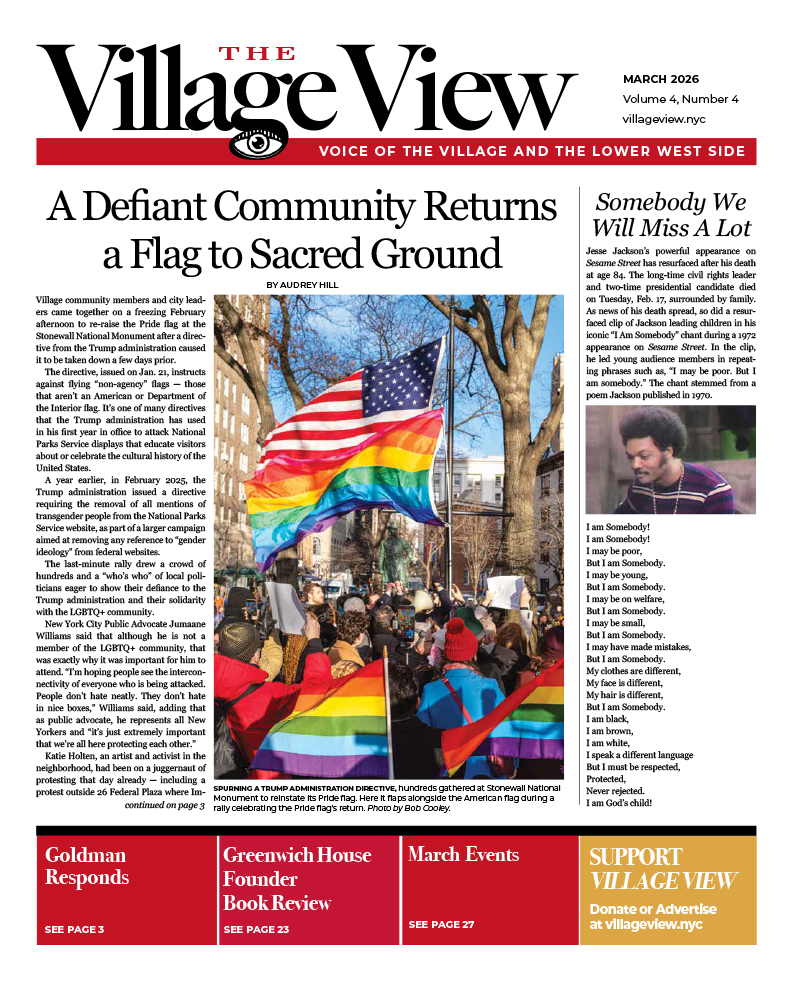
Forcing the grid on the city disrupted many established areas, including Greenwich Village. Many of the farm subdivisions had their streets dissolved into the new plan and the names changed at the same time. Many named streets in the Village were changed to numbered streets, even though they didn’t conform to the new grid. Allowing a 4th Street to change direction that denied the grid causes confusion. Deciding to extend 10th, 11th and 12th, but not 9th, 8th or anything below that number, is illogical. It would have been more logical that all streets west of 6th Avenue change to the named designation that they had been for many years.
Even when the advent of subways forced a whole new path for transportation, dictating a straight shot between downtown and midtown in the 20th century, the avenues did not take a logical form. Whereas most of the avenues in the new grid plan originate at Houston Street, there were plenty of deviations.
In 1807, only Broadway and the Bowery were main North-South thoroughfares, merging at Astor Place. The present Bowery retains that name only up to East 6th Street. From 6th to 14th Streets and Union Square, it is now Fourth Avenue. The section between 14th and 17th Streets was eliminated with the creation of Union Square. From 17th to 23rd Streets, the Bowery is now part of Broadway. Broadway itself had ended at Union Square for a while, but later joined with Bloomingdale Road running up to the west side of Manhattan.
3rd and 4th Avenue don’t start until 6th Street, due to the dominance of the Bowery south of 6th Street.
5th Avenue was truncated at Washington Square Park, though it had previously continued south to Houston Street.
6th Avenue had begun at Carmine Street, but with the subways was extended down to Franklin Street and Church Street in Tribeca, making it a true outlier of the avenues.
7th Avenue begins at Greenwich Avenue, so when it was extended through the Village, it was named 7th Avenue South down to Carmine Street, with a new set of building numbers unrelated to the north stretch, causing confusion to this day. South of Carmine, the avenue is joined to Varick Street, until it terminates at Leonard and West Broadway in Tribeca. Why was Varick’s name and numbering not applied to the extension?
8th Avenue had begun at 13th Street, but was cut into the Village at an angle down to Abingdon Square, with an awkward merge with Hudson Street.
9th Avenue begins at Gansevoort Street in the Meatpacking District and remains there today.
10th Avenue also has its origin at Gansevoort Street, but in this case, created out of landfill in the Hudson River, the same as this part of Washington Street and West Street. The fiction-like 13th Avenue and Bloomfield Street are still mapped as part of Gansevoort Peninsula, a landfill, but are no longer streets.
11th and 12th Avenues don’t begin until 22nd Street, emerging from West Street/Lincoln Highway on our maps. 12th Avenue is virtually all built on landfill in the Hudson River, ending at 59th Street, the top of the Hudson River Park.
If we had the chance to do it over again, do you think we could have done a better job?
Brian J. Pape is a citizen architect in private practice, serving on the Manhattan District 2 Community Board Executive Committee, the Landmarks Committee, the State Liquor Authority Committee, and Street Activities & Resiliency Committee, (speaking personally, and not in an official capacity). He is co-chair of the American Institute of Architects NY Design for Aging Committee, and Historic Buildings, Housing, and PassiveHaus Committee member. He is a LEED-AP “Green” certified architect, a journalist specializing in architecture and urban subjects. He is appointed to the Waterfront Code Committee (2023), the Use & Accessibility sub-Committee, part of NYC Building Codes.