
HISTORY NOW!
Changing Streets and Names: West 4th Street
BY BRIAN J PAPE, AIA, LEED-AP
The charm of the Village is undeniably wrapped up in the unusual street layouts. But that ‘charminess’ can be confusing. My friend Pat has lived here for years, yet still admits to getting turned around occasionally.
One might say it would be logical to have numbered streets run parallel to each other, in sequence, to easily know where you are. Such is not the case in the West Village. So, why did our ‘city fathers’ (they were all men at the time) make the choices they did?
The Village streets were laid out roughly parallel and perpendicular to the Hudson River, but not squared, with the earliest being Greenwich (Road) Street running up the shore from Wall Street. Many country roads follow older Native American trails, such as Monument Lane.
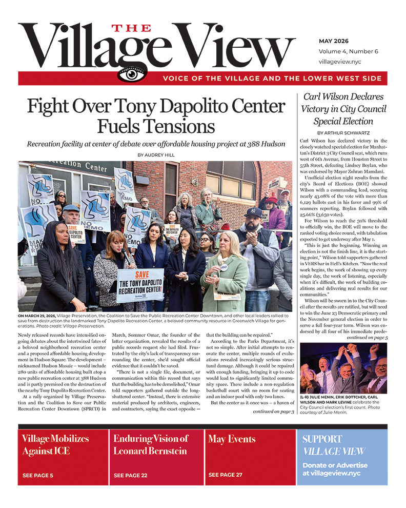
West 4th Street is a prime example to explore and follow the many changes to street names. As a reference point, the future 4th Street will mostly run parallel to both the old Monument Lane to its north with Bleecker, David and Herrings streets to the south and west. It would terminate, like today, at the future Gansevoort Street, just beyond the top of this map.

This 1807 map was by William Bridges, city surveyor, prior to the establishment of the 1811 grid street layout. Credit: NYPL Archives.
Chester Street
West 4th Street, between Bank and Christopher streets, was called Chester Street in 1803. It was then William Street, then Asylum Street until it became part of 4th Street in 1833. There’s another William Street further south.
After 1833, the numbered streets were divided into east and west, from 5th Avenue. Prior to this change, the numbering would start at the Hudson shore and increase as it went east.
But Chester Street was isolated from other streets below Christopher Street, across some farmland to the south, where Science Street ran only a few blocks from Sullivan Street to Broadway, near NYU. Science Street would later become part of 4th Street. Further east, across a ‘super-block’ was Morris Street, running east from the Bowery. It, too, would be renamed 4th Street.
The Grid Pattern
The city fathers, after attempting several plans, decided to lay out the streets in a uniform grid pattern in 1807-1811. By that time, Village streets, as well as much of the city south of Houston Street, were already named and developed.
As shown in the 1834 map, 4th Street has been extended beyond Bowery and the new Washington Square, but it bends northward inexplicably at 6th Avenue. We see 1st Street established in the new grid just above Houston Street east of the Bowery, with 4th Street being the first numbered street to venture further west from Bowery. This street layout would remain intact until the subways were created and avenues extended.
Spencer Place
Fourth Street between 7th Avenue or Christopher and 10th streets was once named Spencer Place. According to the Designation Report of 1969, 7th Avenue South now cuts through part of the site of Senator Mark Spencer’s home. The Spencer house, in a formal setting with landscaped grounds on all four sides, was set back some distance from both Christopher and Amos (10th) streets. Across the front of this elegant one-story house was a splendid portico with eight Ionic columns, facing West 4th Street. A centrally located front door was flanked on either side by floor-length windows with double-hung sashes. On the 10th Street side, a long wing extended back along the property line to the stable, thus effectively enclosing the rear gardens for privacy. Copman’s Nursery, at the Christopher Street corner of West 4th, added to the verdant quality of the block. A house such as this, set in ample grounds, helps us realize what charming Village sites have been lost in the name of progress. Today on 10th Street, only one building remains on this short Spencer Place block, after the cutting through of 7th Avenue. It is the north side of a four-story 1872 brick building which fronts on 231 West 4th Street.
At the north end of West 4th Street, on the east side between Horatio and 13th streets, the corner building (No. 5 Horatio Street) was erected in 1847-48. There are four attractive houses built in 1868, each four stories high over a basement, with mansard roofs. All but the corner house retain their stoops, so characteristic of the French Second Empire style of the 1860s. Of the row, No. 349 West 4th Street is the best preserved. On the west side, the 1811 grid of 13th Street meets the old street layout of Gansevoort. The nine-story brick loft building built in 1912, which fills the east end of the block and the large playground at the western end, have completely altered an entire city block which once was the site of 30 houses, three sizable livery stables and Public School No. 124.
Which Way is Up?
In 1834, all the other Village streets are named, not numbered. So, perhaps the city fathers didn’t think it would be a problem to have a numbered street, 4th Street, turn from an east-west street to a north-south street. First Street only runs from Bowery to Avenue A, 2nd Street ends at Bowery, 3rd Street ends at 6th Avenue while 5th, 6th and 7th streets all end at Bowery. Eighth and 9th streets end at 6th Avenue.
So, why couldn’t 4th Street (and the 10-12 streets) also have ended at 6th Avenue to keep some sense of the Village streets? Obviously, someone wanted more numbered streets to continue over to the Hudson River, thus creating this mess. Our West 4th Street now has to contend with a slew of odd numbered streets crossing its path. Amos was changed to 10th Street, Hammond was changed to 11th Street and Cornelia was changed to
12th Street.
Despite almost 200 years of this mismatch of streets, it’s still hard to figure out.


Trackbacks/Pingbacks